
The Pack contains associated resources for the learning experience, typically in the form of articles and videos. There is a teacher Pack (with only teacher information) and a student Pack (which contains only student information). As a teacher, you can toggle between both to see everything.
Here are the teacher pack items for West and Central Africa: Geographic Passport:


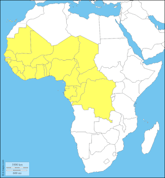
In this experience, students are introduced to the physical geography of West and Central Africa. They identify all 24 countries and major bodies of water on a map. Then they create a map that illustrates some of the geographical features of the region. Next, students research one of the countries and report on their findings. Finally, students research and explain one of the environmental challenges for this region. Objectives:
West and Central Africa is an enormous chunk of the continent, containing 24 separate countries. In this experience, you will explore the physical features and climates of this region as well as some of the specific countries and their environmental challenges.
Objectives:

West and Central Africa is different from North Africa in several important ways, such as climate and physical features. Make a prediction about the geographic characteristics of West and Central Africa. Don’t worry if you guess wrong. You’ll learn the facts about West and Central Africa in this experience.
Answers will vary. The simplest correct answer is that this area of Africa is much wetter than North Africa; instead of desert, it is predominantly savanna, woodland, forest, and wetlands. Tell students they will learn the answers as they proceed to the next scene.
When everyone is ready to continue, unlock the next scene.
