Add a Curriculum Bundle to Your Account!
Please select a bundle.



The Pack contains associated resources for the learning experience, typically in the form of articles and videos. There is a teacher Pack (with only teacher information) and a student Pack (which contains only student information). As a teacher, you can toggle between both to see everything.
Here are the teacher pack items for The Lewis & Clark Expedition:

Overview In this experience, students begin by making observations about an animated map showing the growth of U.S. land claims through 1800. Then they learn about the Louisiana Purchase and identify cause-and-effect relationships connected to it. Next, they read about the Corps of Discovery and Sacagawea’s contributions to the expedition. Finally, they research and prepare a short presentation about places along the expedition’s route, plants and animals recorded during the journey, or Indigenous tribes and individuals the Corps encountered. Students collaborate in small groups for Scene 4. Each group divides three research tasks among its members. If you have access to leveled readers that include stories about the Lewis & Clark expedition or Sacagawea, assign them to the students in parallel to this experience. Estimated duration: 50-90 minutes, depending on how much time you want to give the groups for the research and short presentations in scene 4. Discovery Reading A printable Discovery Reading is included in the student pack as a support for understanding the experience’s core content and concepts. This Discovery Reading is not necessary to complete the experience and serves as an optional support resource. Vocabulary Words: These vocabulary words are used in the experience or connect closely to the standards and content students examine. Students should understand these terms as they work through the experience. Objectives
George Washington served two terms as President and helped establish the new federal government. John Adams became the second President and served one term. In the election of 1800, Thomas Jefferson defeated Adams and became the third President of the United States. In this experience, you will learn about two important events during Jefferson’s presidency: the Louisiana Purchase and the Lewis and Clark expedition. Both events increased U.S. interest and control over lands in the West, where many Native nations already lived.
Objectives
Click the animated map and watch to see how the United States grew between independence and Jefferson’s election in 1800.
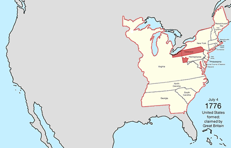
Make an observation about the map.

If students haven’t made the following observations, prompt them with questions: Ask students: What do you think U.S. leaders and settlers knew about the land west of the Mississippi River? Explain that U.S. leaders and settlers had some information about western lands from maps, traders, trappers, and earlier European expeditions. However, their knowledge of much of the region was limited. Native nations had lived in and traveled across these lands for generations, with extensive knowledge of the land, rivers, plants, animals, and travel routes.
When everyone is ready to continue, unlock the next scene.


