Add a Curriculum Bundle to Your Account!
Please select a bundle.



The Pack contains associated resources for the learning experience, typically in the form of articles and videos. There is a teacher Pack (with only teacher information) and a student Pack (which contains only student information). As a teacher, you can toggle between both to see everything.
Here are the teacher pack items for The Trail of Tears:

Overview In this experience, students make observations about an 1870 U.S. census map and learn that many Indigenous people were not included in the population shown. Then, they learn about the “Five Civilized Tribes” of the Southeast and create a concept map about their cultures and communities. Next, they learn about the forced removal of the Cherokee and explain why it became known as the Trail of Tears. Finally, they watch a video about the Cherokee alphabet and research the culture, history, or life today of one of the five tribes. If you have access to leveled readers that describe the Southeastern tribes or Indian Territory, assign them to the students in parallel to this experience. Estimated duration: 35-45 minutes Discovery Reading A printable Discovery Reading is included in the student pack as a support for understanding the experience’s core content and concepts. This Discovery Reading is not necessary to complete the experience and serves as an optional support resource. Vocabulary Words: These vocabulary words are used in the experience or connect closely to the standards and content students examine. Students should understand these terms as they work through the experience. Objectives
In this unit, you are learning about American settlers and immigrants moving west. The western lands were not empty or simply waiting for settlers to arrive. Native nations had lived on and governed these lands for many generations. In this lesson, you will learn how westward settlement affected the lands, communities, and ways of life of different tribes in the Southeastern United States.
Objectives
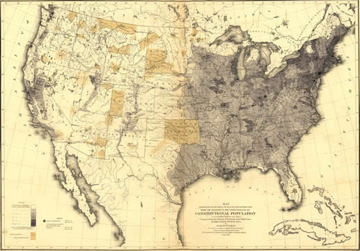
U.S. Population Distribution, based on the 1870 Census
Study the map shown above. Turn and discuss it with a classmate. Record an observation about the map. If someone has already posted your observation, try to think of something else to post.
Table Instructions

Students may make the following observations: If students do not notice the small text about the “Constitutional Population,” point it out. Explain that the map does not show everyone who lived on these lands. Many Indigenous people were not included in the population totals used to create the map. As a result, areas where Native nations lived may appear to have few or no people. Also point out Indian Territory on the map. Explain that this was a name the U.S. government used for lands set aside for Native nations. Some Native nations had been forced from their homelands farther east and moved to Indian Territory. Ask students: How might this map give someone an incomplete picture of who lived in the West?
When everyone is ready to continue, unlock the next scene.


